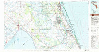
1981 Map of Fort Pierce
USGS Topo · Published 1982About this map
Lake Okeechobee dominates the western interior of this 1981 survey, where the Kissimmee River and various canals like the St Lucie Canal manage the drainage of the Allapattah Flats. This era shows a clear distinction between the developing coastal corridor and the rural cattle and citrus lands to the west. Along the Atlantic, the Florida East Coast and Seaboard Coast Line railroads parallel the shore, connecting established towns like Fort Pierce, White City, and Stuart. The transition from the wilder Savannas State Reserve to the growing residential footprints of Port St Lucie and Jensen Beach is evident. To the west, small rail stops and settlements such as Indiantown, Sherman, and Cypress Quarters illustrate the inland economy's reliance on transport links to the coast and the water management systems of the St Lucie Lock and Dam.
Find a feature on this map
84 named features on this map. Tap any name to fly to it.
Don’t see what you’re looking for? This feature index may not catch every label — zoom into the map to look around manually.
Map Details
Editions of this 1981 Fort Pierce Map
This is the sole edition of this map. No revisions or reprints were ever made.
Other maps of this area

1948 · Palm City
USGS Topo · 1:24,000

1948 · Ankona
USGS Topo · 1:24,000

1948 · Rood
USGS Topo · 1:24,000

1948 · St. Lucie Inlet
USGS Topo · 1:24,000

1948 · Gomez
USGS Topo · 1:24,000

1948 · Hobe Sound
USGS Topo · 1:24,000

1948 · Jupiter
USGS Topo · 1:24,000

1948 · Eden
USGS Topo · 1:24,000

1948 · Indrio
USGS Topo · 1:24,000

1949 · Rood
USGS Topo · 1:24,000