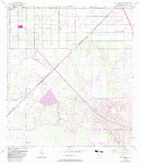
1953 Map of Fort Pierce SW
USGS Topo · Published 1983About this map
Port St Lucie emerges from the South Florida wetlands in this survey, showing the transition from a drainage-dependent landscape to a planned residential community. The infrastructure of the Florida East Coast railway and the newer Florida's Turnpike Toll Road cut diagonally across the terrain, indicating the transport corridors that fueled regional growth. The map illustrates an extensive network of drainage features like the Rim Ditch, Canal systems, and numerous Spoil Bank markings, which were essential for reclaiming the low-lying ground. Localized landmarks such as a Landing Field and several scattered Flowing Wells provide insight into the early water management and private aviation needs of the area before its mid-century transformation into a major population center.
Find a feature on this map
12 named features on this map. Tap any name to fly to it.
Don’t see what you’re looking for? This feature index may not catch every label — zoom into the map to look around manually.
Map Details
Editions of this 1953 Fort Pierce SW Map
4 editions found

Other maps of this area

1948 · Palm City
USGS Topo · 1:24,000

1948 · Ankona
USGS Topo · 1:24,000

1949 · Fort Pierce
USGS Topo · 1:24,000

1949 · Fort Pierce NW
USGS Topo · 1:24,000

1950 · Ankona
USGS Topo · 1:24,000

1950 · Fort Pierce
USGS Topo · 1:24,000

1950 · Palm City
USGS Topo · 1:24,000

1950 · Fort Pierce NW
USGS Topo · 1:24,000

1953 · Okeechobee 1 SE
USGS Topo · 1:24,000

1953 · Okeechobee 4 NE
USGS Topo · 1:24,000