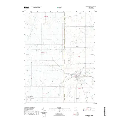
2019 Map of Fort Recovery
USGS Topo · Published 2019About this map
The Ohio Indiana state line bisects this landscape, separating the village of Fort Recovery from its neighboring communities in Jay and Mercer counties. This survey reflects a deeply established agricultural and drainage network, where natural watercourses like the Wabash River and Salamonie River are supplemented by man-made channels such as Grissom Ditch and Young Ditch. Local history is anchored by numerous burial grounds, including the Old Pioneer Cem and Green Mound Cem near the town center, and the isolated Pisgah Cem further south. The straight trajectory of Treaty Line Rd and Ohio Indiana State Line Rd underscores the structured rectilinear surveying of the region. Small settlements like Salamonia, Macedon, and Monterey remain connected by a dense grid of rural roads, tracing the persistence of 19th-century settlement patterns into the modern era.
Find a feature on this map
72 named features on this map. Tap any name to fly to it.
Don’t see what you’re looking for? This feature index may not catch every label — zoom into the map to look around manually.
Map Details
Editions of this 2019 Fort Recovery Map
This is the sole edition of this map. No revisions or reprints were ever made.
Other maps of this area

1908 · St. Henry
USGS Topo · 1:62,500

1911 · Berne
USGS Topo · 1:48,000

1914 · Celina
USGS Topo · 1:62,500

1915 · Fort Recovery
USGS Topo · 1:48,000

1918 · Fort Recovery
USGS Topo · 1:62,500

1944 · Celina
USGS Topo · 1:62,500

1953 · Muncie
USGS Topo · 1:250,000

1956 · Muncie
USGS Topo · 1:250,000

1960 · Fort Recovery
USGS Topo · 1:24,000
1960 · Erastus
USGS Topo · 1:24,000