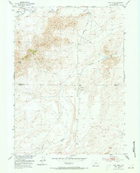
1951 Map of Fort Ridge
USGS Topo · Published 1973About this map
The Emigrant Trail cuts across this high-plains landscape, tracing a historic path of westward expansion along the Sweetwater River. In the early 1950s, the terrain was defined by the intersection of early frontier history and modern energy exploration, marked by the presence of an Oil Tank and Station 8 south of the Natrona and Carbon County line. Of particular significance to historians and genealogists are the Sweetwater Pony Express Sta (Ruins) located in the northwest, serving as a physical marker of the mail route's legacy. The topography is dominated by the prominent elevation of Fort Ridge and the complex geological formations of the Rocks, while seasonal drainage like Arkansas Creek patterns the lower elevations. The map documents a period when the vast open ranges of central Wyoming were still sparsely developed, primarily utilized for livestock and early petroleum activity.
Find a feature on this map
10 named features on this map. Tap any name to fly to it.
Don’t see what you’re looking for? This feature index may not catch every label — zoom into the map to look around manually.
Map Details
Editions of this 1951 Fort Ridge Map
3 editions found
Other maps of this area

1951 · Benton Basin SW
USGS Topo · 1:24,000

1951 · Pathfinder Reservoir NW
USGS Topo · 1:24,000

1951 · Independence Rock
USGS Topo · 1:24,000

1951 · Fort Ridge
USGS Topo · 1:24,000

1953 · Pathfinder Reservoir SW
USGS Topo · 1:24,000

1953 · Buzzard Ranch
USGS Topo · 1:24,000

1953 · Spanish Mine
USGS Topo · 1:24,000

1955 · Casper
USGS Topo · 1:250,000

1958 · Casper
USGS Topo · 1:250,000

1959 · Sanford Ranch
USGS Topo · 1:24,000