
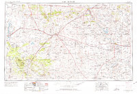
1954 Map of Fort Sumner
USGS Topo · Published 1964About this map
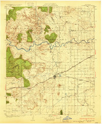
The high plains and mesas of east-central New Mexico are defined by the vital waters of the Pecos River and the industrial backbone of the Southern Pacific and Atchison Topeka and Santa Fe railroads. During the mid-twentieth century, this region served as a critical transportation corridor where major routes like U.S. 60 and U.S. 54 intersect at the rail hub of Vaughn. The map captures a landscape of cattle ranching and scattered settlements, from the riverside center of Fort Sumner to the western slopes of the Gallinas Mountains within the Cibola National Forest. To the north, the Guadalupe Mine indicates the mineral interests of the era, while the Alamogordo Reservoir represents the essential water management of the semi-arid basin. High mesas such as Conejos Mesa and Duran Mesa dominate the topography between the deep cuts of Pintada Canyon and Canyon Blanco.
Find a feature on this map
68 named features on this map. Tap any name to fly to it.
Don’t see what you’re looking for? This feature index may not catch every label — zoom into the map to look around manually.
Map Details
Editions of this 1954 Fort Sumner Map
3 editions found
Other maps of this area

1890 · Bernal
USGS Topo · 1:125,000

1891 · Bernal
USGS Topo · 1:125,000

1892 · San Pedro
USGS Topo · 1:125,000

1892 · Corazon
USGS Topo · 1:125,000
1894 · Corazon
USGS Topo · 1:125,000
1894 · Bernal
USGS Topo · 1:125,000

1894 · Lamy
USGS Topo · 1:125,000

1917 · Estancia
USGS Topo · 1:125,000

1918 · Oscura Peak
USGS Topo · 1:125,000
1930 · Tucumcari
USGS Topo · 1:125,000