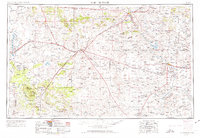
1954 Map of Fort Sumner
USGS Topo · Published 1974About this map
Fort Sumner and Santa Rosa anchor this mid-century survey of East-Central New Mexico, a region defined by high plains transit and the critical waters of the Pecos River. The map documents a landscape where major transportation corridors intersect, including the junction of the Atchison Topeka and Santa Fe and Southern Pacific railroads at Vaughn. These rail lines, alongside historical routes like U.S. 66 and U.S. 54, illustrate the area's role as a vital crossroads for southwestern commerce.
Find a feature on this map
63 named features on this map. Tap any name to fly to it.
Don’t see what you’re looking for? This feature index may not catch every label — zoom into the map to look around manually.
Map Details
Editions of this 1954 Fort Sumner Map
3 editions found

Other maps of this area

1890 · Bernal
USGS Topo · 1:125,000

1891 · Bernal
USGS Topo · 1:125,000

1892 · San Pedro
USGS Topo · 1:125,000

1892 · Corazon
USGS Topo · 1:125,000

1894 · Corazon
USGS Topo · 1:125,000

1894 · Bernal
USGS Topo · 1:125,000

1894 · Lamy
USGS Topo · 1:125,000

1917 · Estancia
USGS Topo · 1:125,000

1918 · Oscura Peak
USGS Topo · 1:125,000

1930 · Tucumcari
USGS Topo · 1:125,000