
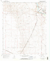
1965 Map of Fort Sumner West
USGS Topo · Published 1968About this map
Fort Sumner sits at the eastern edge of this landscape, where the Pecos River valley meets the high plains of De Baca County. This mid-1960s survey captures a transition between traditional ranching and modern infrastructure, dominated by the long diagonal sweep of the Atchison Topeka and Santa Fe railroad. The vital nature of water in this semi-arid environment is evidenced by the density of named water features, including the Main Canal feeding into Trujillo Creek and a network of family-named windmills. Scattered agricultural outposts like Steele Ranch, Vaughn Ranch, and McCollum Ranch anchor the rural territory, while landmarks such as the Water Tank and several gravel pits mark the industrial activity along the rail line. Individual sites like Goldberg Windmill and Jensen Well provide precise location data for those researching local family history or land use.
Find a feature on this map
26 named features on this map. Tap any name to fly to it.
Don’t see what you’re looking for? This feature index may not catch every label — zoom into the map to look around manually.
Map Details
Editions of this 1965 Fort Sumner West Map
2 editions found
Other maps of this area

1954 · Fort Sumner
USGS Topo · 1:250,000

1958 · Fort Sumner
USGS Topo · 1:250,000

1965 · Windmill Draw
USGS Topo · 1:24,000

1966 · West Camp
USGS Topo · 1:24,000

1966 · Alamo Ranch
USGS Topo · 1:24,000

1966 · Ricardo
USGS Topo · 1:24,000

1966 · Alamogordo Dam
USGS Topo · 1:24,000

1968 · Fort Sumner East
USGS Topo · 1:24,000

1968 · Bonner Lake
USGS Topo · 1:24,000

1968 · Twin Mesa
USGS Topo · 1:24,000