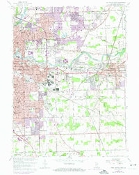
1963 Map of Fort Wayne East
USGS Topo · Published 1974About this map
Johnny Appleseed Memorial Park and the winding Maumee River anchor this mid-century look at the eastern expansion of Fort Wayne. This era shows a landscape in transition, where established residential neighborhoods like Maplewood Park and Greendale meet the newer suburban developments of Sunnymede Woods and Anthony Wayne Village. Educational and religious institutions are dense throughout the area, including Concordia Sch, Ind Institute of Technology, and St Charles Borromeo Sch. Industrial footprints and transportation corridors are prominent, defined by the heavy rail lines of the Norfolk and Western and Penn Central, which supported the growth of neighboring New Haven. Along the southern reaches, the map transitions into more open land, dotted with trailer parks and cemeteries like IOOF Cem, illustrating the outward reach of the city's infrastructure during the postwar boom.
Find a feature on this map
71 named features on this map. Tap any name to fly to it.
Don’t see what you’re looking for? This feature index may not catch every label — zoom into the map to look around manually.
Map Details
Editions of this 1963 Fort Wayne East Map
3 editions found
Other maps of this area

1953 · Fort Wayne
USGS Topo · 1:250,000

1953 · Muncie
USGS Topo · 1:250,000

1956 · Muncie
USGS Topo · 1:250,000

1956 · Fort Wayne
USGS Topo · 1:250,000

1956 · Fort Wayne West
USGS Topo · 1:24,000

1956 · Fort Wayne East
USGS Topo · 1:24,000

1956 · Cedarville
USGS Topo · 1:24,000

1957 · Maples
USGS Topo · 1:24,000

1957 · Huntertown
USGS Topo · 1:24,000

1958 · Grabill
USGS Topo · 1:24,000