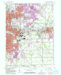
1963 Map of Fort Wayne East
USGS Topo · Published 1982About this map
The confluence of the St Joseph River and the Maumee River shapes the eastern reach of Fort Wayne, where suburban development and institutional grounds met the traditional rail corridors of the early 1960s. Large-scale public facilities like the Fort Wayne State Hospital and Training Center and the Veterans Hosp occupy substantial tracts, while the urban footprint expands into residential pockets such as Greendale and Hacienda Village. The industrial and logistics backbone of the region is visible along the Norfolk and Western and Conrail lines, which cut through New Haven to the east. Notable for genealogists are several historical burial grounds, including the IOOF Cem and St Johns Cem, alongside a dense network of parish schools like St Charles Borromeo Sch and St Henrys Sch that anchored local neighborhoods during this era of growth.
Find a feature on this map
72 named features on this map. Tap any name to fly to it.
Don’t see what you’re looking for? This feature index may not catch every label — zoom into the map to look around manually.
Map Details
Editions of this 1963 Fort Wayne East Map
3 editions found
Other maps of this area

1953 · Fort Wayne
USGS Topo · 1:250,000

1953 · Muncie
USGS Topo · 1:250,000

1956 · Muncie
USGS Topo · 1:250,000

1956 · Fort Wayne
USGS Topo · 1:250,000

1956 · Fort Wayne West
USGS Topo · 1:24,000

1956 · Fort Wayne East
USGS Topo · 1:24,000

1956 · Cedarville
USGS Topo · 1:24,000

1957 · Maples
USGS Topo · 1:24,000

1957 · Huntertown
USGS Topo · 1:24,000

1958 · Grabill
USGS Topo · 1:24,000