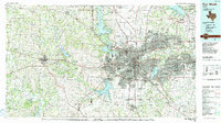
1985 Map of Fort Worth
USGS Topo · Published 1991About this map
The West Fork Trinity River and its various impoundments anchor this 1980s look at the growing North Texas metropolitan area. This survey illustrates the dense suburban expansion between Fort Worth and Arlington, including established communities like White Settlement, Bedford, and Haltom City. Large-scale infrastructure projects are prominent, from the sprawling Dallas-Fort Worth International Airport in the northeast to the Carswell Air Force Base near Lake Worth.
Find a feature on this map
147 named features on this map. Tap any name to fly to it.
Don’t see what you’re looking for? This feature index may not catch every label — zoom into the map to look around manually.
Map Details
Editions of this 1985 Fort Worth Map
2 editions found
Other maps of this area

1889 · Granbury
USGS Topo · 1:125,000

1890 · Stephenville
USGS Topo · 1:125,000

1891 · Weatherford
USGS Topo · 1:125,000

1891 · Dallas
USGS Topo · 1:125,000

1891 · Palo Pinto
USGS Topo · 1:125,000

1891 · Cleburne
USGS Topo · 1:125,000

1893 · Dallas
USGS Topo · 1:125,000

1893 · Weatherford
USGS Topo · 1:125,000

1894 · Cleburne
USGS Topo · 1:125,000

1894 · Fort Worth
USGS Topo · 1:125,000