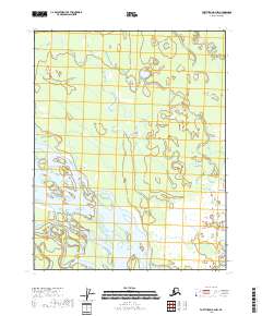
2018 Map of Fort Yukon B-2 NW
USGS Topo · Published 2018About this map
The Yukon River carves through a vast, intricate network of wetlands and shifting channels within the Yukon Flats of interior Alaska. This 2018 survey reveals a landscape dominated by aquatic complexity, where the main river artery is fed by meandering tributaries like Squirrel Cr and the Sucker River. The terrain is characterized by a dense concentration of thaw lakes and braided streams, typical of the low-lying basin where the river system slows and spreads. These features illustrate the dynamic nature of the subarctic floodplain, where seasonal water levels and ice action constantly reshape the banks. While modern in its mapping standards, the sheet preserves the traditional names and hydrologic patterns of a region where the water itself defines the boundaries of travel and settlement.
Find a feature on this map
8 named features on this map. Tap any name to fly to it.
Don’t see what you’re looking for? This feature index may not catch every label — zoom into the map to look around manually.
Map Details
Editions of this 2018 Fort Yukon B-2 NW Map
This is the sole edition of this map. No revisions or reprints were ever made.
Other maps of this area

1951 · Fort Yukon
USGS Topo · 1:250,000

1952 · Fort Yukon C-2
USGS Topo · 1:63,360

1952 · Fort Yukon C-3
USGS Topo · 1:63,360

1955 · Fort Yukon C-3
USGS Topo · 1:63,360

1956 · Fort Yukon B-3
USGS Topo · 1:63,360

1956 · Fort Yukon B-2
USGS Topo · 1:63,360

1956 · Fort Yukon
USGS Topo · 1:250,000
1956 · Fort Yukon C-2
USGS Topo · 1:63,360
2018 · Fort Yukon B-3 NE
USGS Topo · 1:25,000
2018 · Fort Yukon C-3 SE
USGS Topo · 1:25,000