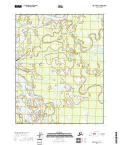
2018 Map of Fort Yukon C-3 SE
USGS Topo · Published 2018About this map
Fort Yukon sits at the western edge of this vast network of braided channels and subarctic wetlands where the Porcupine River and Sucker River converge toward the larger Yukon River. The settlement's local infrastructure is detailed through a systematic street grid including Spruce Street and East Third Avenue, leading toward the Fort Yukon Airport. Beyond the town, the landscape is defined by the shifting hydrology of the Yukon Flats, characterized by seasonal water bodies like Eightmile Slough and Vllota Slough. Large interior lakes such as Sixmile Lake, Emile Lake, and Laura Lake are scattered across the interior, while Jenny Island sits within the main river channel, illustrating the dynamic nature of these northern waterways in the early twenty-first century.
Find a feature on this map
30 named features on this map. Tap any name to fly to it.
Don’t see what you’re looking for? This feature index may not catch every label — zoom into the map to look around manually.
Map Details
Editions of this 2018 Fort Yukon C-3 SE Map
This is the sole edition of this map. No revisions or reprints were ever made.
Other maps of this area

1951 · Fort Yukon
USGS Topo · 1:250,000

1952 · Fort Yukon C-2
USGS Topo · 1:63,360

1952 · Fort Yukon C-3
USGS Topo · 1:63,360

1955 · Fort Yukon C-3
USGS Topo · 1:63,360

1956 · Fort Yukon B-3
USGS Topo · 1:63,360

1956 · Fort Yukon B-2
USGS Topo · 1:63,360

1956 · Fort Yukon
USGS Topo · 1:250,000
1956 · Fort Yukon C-2
USGS Topo · 1:63,360
2018 · Fort Yukon B-3 NE
USGS Topo · 1:25,000
2018 · Fort Yukon C-3 NE
USGS Topo · 1:25,000