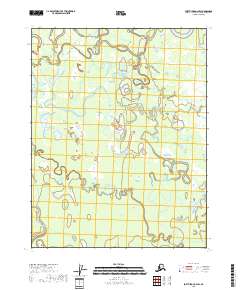
2018 Map of Fort Yukon C-2 SW
USGS Topo · Published 2018About this map
The Sucker River and Grass River converge and wind through this low-lying Alaksan interior landscape, illustrating the complex hydrology of the Yukon-Koyukuk region. This 2018 survey documents a shifting network of wetlands and seasonal watercourses, where features like Seventeenmile Slough and Eightmile Slough serve as critical indicators of the local drainage patterns. The presence of Old Man Lake in the northeast corner, along with the meandering path of Bear Blanket Slough, highlights an environment dominated by alluvial processes and seasonal fluctuations. These waterways are the primary landmarks in an area defined by its lack of permanent road infrastructure, emphasizing the historical and modern reliance on river systems for navigation and access in the far north.
Find a feature on this map
12 named features on this map. Tap any name to fly to it.
Don’t see what you’re looking for? This feature index may not catch every label — zoom into the map to look around manually.
Map Details
Editions of this 2018 Fort Yukon C-2 SW Map
This is the sole edition of this map. No revisions or reprints were ever made.
Other maps of this area

1951 · Fort Yukon
USGS Topo · 1:250,000

1952 · Fort Yukon C-2
USGS Topo · 1:63,360

1952 · Fort Yukon C-3
USGS Topo · 1:63,360

1955 · Fort Yukon C-3
USGS Topo · 1:63,360

1956 · Fort Yukon B-3
USGS Topo · 1:63,360

1956 · Fort Yukon B-2
USGS Topo · 1:63,360

1956 · Fort Yukon
USGS Topo · 1:250,000
1956 · Fort Yukon C-2
USGS Topo · 1:63,360
2018 · Fort Yukon B-3 NE
USGS Topo · 1:25,000
2018 · Fort Yukon C-3 NE
USGS Topo · 1:25,000