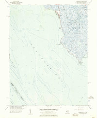
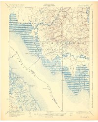
1956 Map of Fortescue
USGS Topo · Published 1957About this map
Fortescue sits at the edge of the Delaware Bay, serving as a focal point for this coastal Cumberland County landscape in the mid-1950s. The settlement is defined by its relationship to the water, bordered by Fortescue Creek and the sweeping Fortescue Beach. This survey captures a highly intricate marshland environment within the Downe Public Hunting and Fishing Grounds, where a dense network of tidal waterways like Oranoaken Creek, Straight Creek, and the The Three Mouths intersect. These wetlands are dotted with family-named or descriptive landmarks such as Wilmas Pond, McCormick Pond, and King Pond. Offshore, the map details the maritime hazards and navigational aids of the bay, including Cross Ledge and Joe Flogger Shoal, alongside the state boundary dividing New Jersey and Delaware waters.
Find a feature on this map
40 named features on this map. Tap any name to fly to it.
Don’t see what you’re looking for? This feature index may not catch every label — zoom into the map to look around manually.
Map Details
Editions of this 1956 Fortescue Map
4 editions found
Other maps of this area

1890 · Maurice Cove
USGS Topo · 1:62,500

1890 · Bay Side
USGS Topo · 1:62,500

1890 · Bridgeton
USGS Topo · 1:62,500

1891 · Maurice Cove
USGS Topo · 1:62,500

1894 · Bay Side
USGS Topo · 1:62,500

1894 · Bridgeton
USGS Topo · 1:62,500

1899 · Vineland
USGS Topo · 1:125,000

1919 · Vineland
USGS Topo · 1:125,000
1931 · Bay Side
USGS Topo · 1:62,500

1934 · Bowers
USGS Topo · 1:48,000
Featured Places
- Downe Township, NJ
- Fortescue, Downe Township
- Raybins Beach, Downe Township
- Kent County, DE
- Cumberland County, NJ