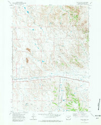
1971 Map of Fortin Draw
USGS Topo · Published 1981About this map
Rozet Field and its surrounding extraction landscape define this 1970s survey of Campbell County. The terrain is characterized by the complex drainage of the Little Powder River and Donkey Creek, set against the dramatic elevations of the Deer Creek Breaks and the Rochelle Hills. This map documents a period of industrial activity in the Powder River Basin, evidenced by the Burlington Northern railroad corridor and local energy-related operations like the Baumfalk Mine.
Find a feature on this map
19 named features on this map. Tap any name to fly to it.
Don’t see what you’re looking for? This feature index may not catch every label — zoom into the map to look around manually.
Map Details
Editions of this 1971 Fortin Draw Map
2 editions found
Other maps of this area

1954 · Gillette
USGS Topo · 1:250,000

1955 · Gillette
USGS Topo · 1:250,000

1958 · Gillette
USGS Topo · 1:250,000

1962 · Gillette
USGS Topo · 1:250,000

1971 · Coyote Draw
USGS Topo · 1:24,000

1971 · Coon Track Creek
USGS Topo · 1:24,000

1971 · Rozet
USGS Topo · 1:24,000

1971 · Gillette East
USGS Topo · 1:24,000
1971 · Rozet NW
USGS Topo · 1:24,000

1971 · Green Hill
USGS Topo · 1:24,000