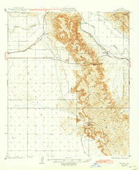
1929 Map of Fortuna
USGS Topo · Published 1943About this map
The Fortuna Mine stands as a focal point in the southern reaches of the Gila Mountains, marking a period of intense mineral extraction in the Yuma region. The landscape is defined by the stark divide between the high peaks of Muggins Mountains and the broad Gila Valley, where the Gila River winds past the Laguna Mts. Transportation and communication infrastructure are central to this 1920s-era survey, showing the Southern Pacific railroad corridor and the Electric Gas and Water Telegraph Line crossing through Telegraph Pass. Small rail-aligned settlements like Blaisdell, Fortuna, and Ligurta serve as the primary human outposts in this desert terrain. The presence of the Tinajas Altas Road and landmarks like Granite Spur and Clotho's Temple reflect the early routes used by surveyors and miners navigating the arid Arizona borderlands.
Find a feature on this map
16 named features on this map. Tap any name to fly to it.
Don’t see what you’re looking for? This feature index may not catch every label — zoom into the map to look around manually.
Map Details
Editions of this 1929 Fortuna Map
4 editions found
Other maps of this area

1903 · Yuma
USGS Topo · 1:125,000

1905 · Yuma
USGS Topo · 1:125,000

1926 · Fortuna
USGS Topo · 1:62,500

1926 · Wellton
USGS Topo · 1:62,500

1929 · Fortuna
USGS Topo · 1:62,500

1929 · Laguna
USGS Topo · 1:62,500

1929 · Wellton
USGS Topo · 1:62,500

1940 · Yuma
USGS Topo · 1:62,500

1942 · Yuma
USGS Topo · 1:250,000

1943 · Laguna
USGS Topo · 1:62,500