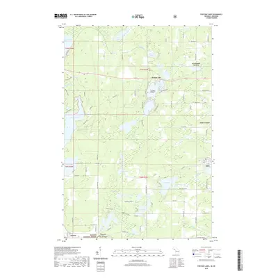
2019 Map of Fortune Lakes
USGS Topo · Published 2019About this map
Fortune Lake and its surrounding water bodies anchor this section of Iron County, where the transition between early mining settlements and protected timberlands is clearly visible. The map captures established communities like Alpha and Pentoga alongside smaller settlements such as New Bristol Location and Dunn Location, which reflect the region's industrial heritage. The southern reaches are dominated by the Nicolet National Forest, illustrating the deliberate preservation of the landscape south of the more developed lakefronts. Diverse water features, from the expansive Chicagon Lake and Lake Emily to the smaller Isaacson Lake and Dam Lake, are connected by a network of drainage ways including Fortune Lake Cr and the branches of Armstrong Creek. Several family and local names persist on the land, from Scaddens Island to numerous roads like Kudwa Rd and Leppiaho Rd, marking the generational footprint of those who worked these northern woods.
Find a feature on this map
92 named features on this map. Tap any name to fly to it.
Don’t see what you’re looking for? This feature index may not catch every label — zoom into the map to look around manually.
Map Details
Editions of this 2019 Fortune Lakes Map
This is the sole edition of this map. No revisions or reprints were ever made.
Other maps of this area

1898 · Iron River
USGS Topo · 1:62,500

1899 · Crystal Falls
USGS Topo · 1:62,500

1939 · Long Lake
USGS Topo · 1:48,000

1941 · Florence
USGS Topo · 1:48,000

1944 · Crystal Falls
USGS Topo · 1:24,000

1944 · Gaastra
USGS Topo · 1:24,000

1944 · Fortune Lakes
USGS Topo · 1:24,000

1945 · Sunset Lake
USGS Topo · 1:24,000

1945 · Kelso Junction
USGS Topo · 1:24,000

1945 · Amasa
USGS Topo · 1:24,000