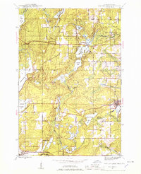
1944 Map of Fortune Lakes
USGS Topo · Published 1978About this map
The Brule River defines the southern boundary of this Iron County landscape, marking the border between Michigan and Wisconsin during the mid-1940s. The region is characterized by an extensive network of waterways, including Chicagon Lake and the chain of First, Second, and Third lakes. Mining and timber heritage is evident through the identification of the New Bristol Location and Dunn Location, which likely housed workers for nearby operations.
Find a feature on this map
35 named features on this map. Tap any name to fly to it.
Don’t see what you’re looking for? This feature index may not catch every label — zoom into the map to look around manually.
Map Details
Editions of this 1944 Fortune Lakes Map
2 editions found
Other maps of this area

1898 · Iron River
USGS Topo · 1:62,500

1899 · Crystal Falls
USGS Topo · 1:62,500

1939 · Long Lake
USGS Topo · 1:48,000

1941 · Florence
USGS Topo · 1:48,000

1944 · Crystal Falls
USGS Topo · 1:24,000

1944 · Gaastra
USGS Topo · 1:24,000

1944 · Fortune Lakes
USGS Topo · 1:24,000

1945 · Sunset Lake
USGS Topo · 1:24,000

1945 · Kelso Junction
USGS Topo · 1:24,000

1945 · Amasa
USGS Topo · 1:24,000