
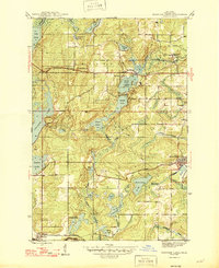
1946 Map of Fortune Lakes
USGS Topo · Published 1946About this map
The Iron County Forest Reserve anchors this mid-century look at Michigan's Upper Peninsula, where the landscape is defined by a dense network of glacial lakes and mining-era industrial footprints. The transition from active resource extraction to public recreation is evident at Bewabic Park on the shores of First Lake, part of the larger Fortune Lakes chain. The map details the scattered residential patterns characteristic of the region's mining history, notably at New Bristol Location and Dunn Location, which served as worker settlements. Transportation corridors are well-established, with the Milwaukee St Paul and Pacific and Chicago and Northwestern railroads cutting through the terrain to connect remote outposts like Pentoga to regional markets. Numerous water bodies, including the sprawling Chicagon Lake and smaller basins like Mastodon Lake, illustrate the complex drainage patterns feeding into Fortune Creek and Alpha Creek.
Find a feature on this map
35 named features on this map. Tap any name to fly to it.
Don’t see what you’re looking for? This feature index may not catch every label — zoom into the map to look around manually.
Map Details
Editions of this 1946 Fortune Lakes Map
2 editions found
Other maps of this area

1898 · Iron River
USGS Topo · 1:62,500

1899 · Crystal Falls
USGS Topo · 1:62,500

1939 · Long Lake
USGS Topo · 1:48,000

1941 · Florence
USGS Topo · 1:48,000

1944 · Crystal Falls
USGS Topo · 1:24,000

1944 · Gaastra
USGS Topo · 1:24,000

1944 · Fortune Lakes
USGS Topo · 1:24,000

1945 · Sunset Lake
USGS Topo · 1:24,000

1945 · Kelso Junction
USGS Topo · 1:24,000

1945 · Amasa
USGS Topo · 1:24,000