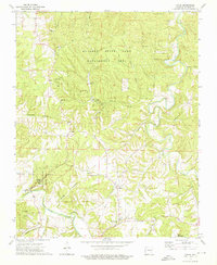
1973 Map of Forum
USGS Topo · Published 1976About this map
The Kings River carves through the Ozark landscape of Madison County, framing a region defined by conservation areas and tight-knit rural communities. This survey documents the sprawling McIlroy State Game Management Area in the north and Withrow Springs State Park to the south, where War Eagle Creek winds past several designated picnic areas and Noark Camp.
Find a feature on this map
30 named features on this map. Tap any name to fly to it.
Don’t see what you’re looking for? This feature index may not catch every label — zoom into the map to look around manually.
Map Details
Editions of this 1973 Forum Map
3 editions found
Other maps of this area

1900 · Eureka Springs
USGS Topo · 1:125,000

1901 · Eureka Springs
USGS Topo · 1:125,000

1945 · Harrison
USGS Topo · 1:250,000

1949 · Harrison
USGS Topo · 1:250,000

1954 · Harrison
USGS Topo · 1:250,000

1957 · Mundell
USGS Topo · 1:24,000

1958 · Hindsville
USGS Topo · 1:24,000

1958 · Harrison
USGS Topo · 1:250,000

1964 · Harrison
USGS Topo · 1:250,000
1972 · Rockhouse
USGS Topo · 1:24,000