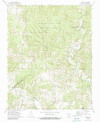
1973 Map of Forum
USGS Topo · Published 1990About this map
Forum and Alabam serve as the primary focal points in this 1970s survey of Madison County, where the landscape is defined by the winding paths of Kings River and War Eagle Creek. The area transitions from the managed wilderness of the Mc Ilroy State Game Management Area in the north to the recreational grounds of Withrow Springs State Park in the southwest. Local history is etched into the terrain through scattered family burial grounds like McClain Cem, Marshall Cem, and Fritts Cem, alongside the Assembly of God Ch. The presence of Old Alabam south of the primary settlement suggests the shifting center of community life over time. Elevated points like the Forum Lookout Tower provide a vantage over a network of hollows, including Houston Hollow and Jelico Hollow, that once shaped the movement of early settlers and their livestock.
Find a feature on this map
33 named features on this map. Tap any name to fly to it.
Don’t see what you’re looking for? This feature index may not catch every label — zoom into the map to look around manually.
Map Details
Editions of this 1973 Forum Map
3 editions found
Other maps of this area

1900 · Eureka Springs
USGS Topo · 1:125,000

1901 · Eureka Springs
USGS Topo · 1:125,000

1945 · Harrison
USGS Topo · 1:250,000

1949 · Harrison
USGS Topo · 1:250,000

1954 · Harrison
USGS Topo · 1:250,000

1957 · Mundell
USGS Topo · 1:24,000

1958 · Hindsville
USGS Topo · 1:24,000

1958 · Harrison
USGS Topo · 1:250,000

1964 · Harrison
USGS Topo · 1:250,000
1972 · Rockhouse
USGS Topo · 1:24,000