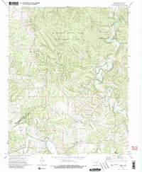
1973 Map of Forum
USGS Topo · Published 1990About this map
War Eagle Creek and the Kings River define the winding drainage patterns of this Madison County landscape in the early 1970s. The small settlements of Forum and Alabam serve as local anchors, while Old Alabam marks an earlier center of habitation to the south. The area is heavily shaped by conservation and recreation, with large tracts dedicated to the McIlroy State Game Management Area and Withrow Springs State Park. Genealogists and local historians will find several family-named landmarks and burial sites, including McClain Cem, Marshall Cem, and Fritts Cem, alongside the Assembly of God Ch. The presence of the Forum Lookout Tower and a utility pipeline cutting across the southern hills illustrates the intersection of natural resource management and infrastructure in this part of the Ozarks.
Find a feature on this map
30 named features on this map. Tap any name to fly to it.
Don’t see what you’re looking for? This feature index may not catch every label — zoom into the map to look around manually.
Map Details
Editions of this 1973 Forum Map
3 editions found
Other maps of this area

1900 · Eureka Springs
USGS Topo · 1:125,000

1901 · Eureka Springs
USGS Topo · 1:125,000

1945 · Harrison
USGS Topo · 1:250,000

1949 · Harrison
USGS Topo · 1:250,000

1954 · Harrison
USGS Topo · 1:250,000

1957 · Mundell
USGS Topo · 1:24,000

1958 · Hindsville
USGS Topo · 1:24,000

1958 · Harrison
USGS Topo · 1:250,000

1964 · Harrison
USGS Topo · 1:250,000
1972 · Rockhouse
USGS Topo · 1:24,000