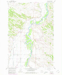
1960 Map of Foster
USGS Topo · Published 1980About this map
The Bighorn River meanders through this landscape, defining a valley carved by complex irrigation networks essential to the development of the Missouri River Basin. Small settlements like Foster and Kingley sit along the drainage paths of Cotters Coulee and Wagon Box Coulee, where the presence of the Low Line Canal and Wagon Box Canal signifies the engineered transformation of Big Horn County for agriculture. Local education in this era was decentralized, anchored by rural landmarks such as Sorrel Horse Sch in the north, Fairview Sch near the center, and Community Sch to the south.
Find a feature on this map
21 named features on this map. Tap any name to fly to it.
Don’t see what you’re looking for? This feature index may not catch every label — zoom into the map to look around manually.
Map Details
Editions of this 1960 Foster Map
2 editions found
Other maps of this area

1894 · Fort Custer
USGS Topo · 1:125,000

1954 · Hardin
USGS Topo · 1:250,000

1954 · Forsyth
USGS Topo · 1:250,000

1957 · Hardin
USGS Topo · 1:250,000

1957 · Forsyth
USGS Topo · 1:250,000

1958 · Forsyth
USGS Topo · 1:250,000

1958 · Hardin
USGS Topo · 1:250,000

1960 · Foster
USGS Topo · 1:24,000

1960 · Ninemile Point
USGS Topo · 1:24,000

1960 · Chimney Creek
USGS Topo · 1:24,000