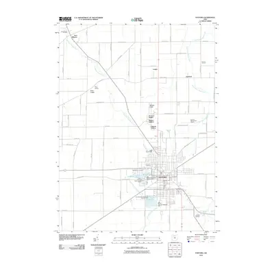
2010 Map of Fostoria
USGS Topo · Published 2010About this map
The industrial and residential center of Fostoria anchors this landscape, surrounded by a complex system of upground reservoirs that managed the local water supply in the early 21st century. These reservoirs, including Lamberjack Lake, Mottram Lake, Mosier Lake, and Daugherty Lake, are clustered near the East Branch Portage River, reflecting the region's managed hydrology. Within the city limits and its residential expansions like Stearns Crest and Caldwells Addition, the map details a grid of urban development that gives way to the agricultural expanses of northwestern Ohio.
Find a feature on this map
77 named features on this map. Tap any name to fly to it.
Don’t see what you’re looking for? This feature index may not catch every label — zoom into the map to look around manually.
Map Details
Editions of this 2010 Fostoria Map
This is the sole edition of this map. No revisions or reprints were ever made.
Other maps of this area

1901 · Fostoria
USGS Topo · 1:62,500

1901 · Bowling Green
USGS Topo · 1:62,500

1901 · Elmore
USGS Topo · 1:62,500

1903 · Bowling Green
USGS Topo · 1:62,500

1903 · Fostoria
USGS Topo · 1:62,500

1903 · Findlay
USGS Topo · 1:62,500

1903 · Elmore
USGS Topo · 1:62,500

1956 · Toledo
USGS Topo · 1:250,000

1958 · Jerry City
USGS Topo · 1:24,000
1958 · Bradner
USGS Topo · 1:24,000