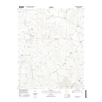
2016 Map of Fountain Head
USGS Topo · Published 2016About this map
Portland and its surrounding Sumner County countryside are defined by a network of creeks and small settlements in this recent survey. The landscape is marked by numerous historic burial grounds including the Old Fountain Head Cem and Old Brush Cem, reflecting generations of local family history. To the north, Sengtown sits near the headwaters of the West Fork Drakes Creek, while the Portland Municipal Airport serves the growing aviation needs of the community. The terrain drops into distinct valleys like Butler Mill Hollow and Buttermilk Hollow in the southeast, where smaller communities such as Sulphura and Rock Bridge are situated. This map documents a modern snapshot of the region's balance between municipal expansion, such as the Portland City Lake, and its rural roots preserved in name and place across the rolling Tennessee uplands.
Find a feature on this map
127 named features on this map. Tap any name to fly to it.
Don’t see what you’re looking for? This feature index may not catch every label — zoom into the map to look around manually.
Map Details
Editions of this 2016 Fountain Head Map
This is the sole edition of this map. No revisions or reprints were ever made.
Other maps of this area

1903 · Nashville
USGS Topo · 1:125,000

1928 · Adolphus
USGS Topo · 1:48,000

1931 · Adolphus
USGS Topo · 1:62,500

1942 · Gallatin
USGS Topo · 1:100,000

1951 · Franklin
USGS Topo · 1:24,000

1953 · Cottontown
USGS Topo · 1:24,000
1954 · Hickory Flat
USGS Topo · 1:24,000

1954 · Adolphus
USGS Topo · 1:24,000

1955 · Bethpage
USGS Topo · 1:24,000

1955 · Gallatin
USGS Topo · 1:24,000