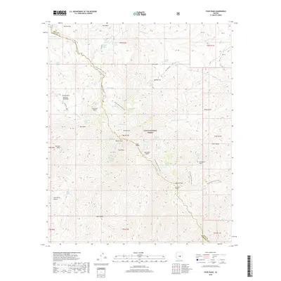
2018 Map of Four Peaks
USGS Topo · Published 2018About this map
Tonto National Forest landscape is defined by the prominent silhouette of the Mazatzal Mountains and the iconic peaks that crown this high desert terrain. The Arizona National Scenic Trail traverses the region from north to south, winding past distinctive landmarks such as Lone Pine Saddle and Black Bear Saddle. The crest is dominated by Four Peaks, including the highest point at Browns Peak, and the nearby Ziltadin Mtn. This environment is punctuated by numerous vital water sources, such as Amethyst Spring and Coyote Spring, which supported travel and habitation across the Gila and Maricopa county line. Further south, the terrain descends toward Buckhorn Mtn and Buckhorn Ridge, illustrating the complex network of canyons and ridges like Cane Spring Canyon that characterize the area's wilderness character.
Find a feature on this map
53 named features on this map. Tap any name to fly to it.
Don’t see what you’re looking for? This feature index may not catch every label — zoom into the map to look around manually.
Map Details
Editions of this 2018 Four Peaks Map
This is the sole edition of this map. No revisions or reprints were ever made.
Other maps of this area

1907 · Roosevelt
USGS Topo · 1:125,000

1909 · Four Peaks
USGS Topo · 1:125,000

1912 · Roosevelt
USGS Topo · 1:125,000

1954 · Mesa
USGS Topo · 1:250,000

1957 · Mesa
USGS Topo · 1:250,000

1958 · Mesa
USGS Topo · 1:250,000

1960 · Mesa
USGS Topo · 1:250,000
1963 · Mine Mountain
USGS Topo · 1:24,000

1964 · Mesa
USGS Topo · 1:250,000
1964 · Greenback Creek
USGS Topo · 1:24,000