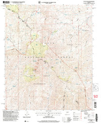
2004 Map of Four Peaks
USGS Topo · Published 2007About this map
Tonto National Forest defines the rugged central Arizona landscape on this 2004 revision, where the Four Peaks Wilderness protects the prominent summits of the Mazatzal Mountains. The sheet is anchored by the high point of Browns Peak and the surrounding high-altitude terrain, marked by a network of seasonal water sources such as Amethyst Spring and Four Peaks Spring No 1.
Find a feature on this map
55 named features on this map. Tap any name to fly to it.
Don’t see what you’re looking for? This feature index may not catch every label — zoom into the map to look around manually.
Map Details
Editions of this 2004 Four Peaks Map
This is the sole edition of this map. No revisions or reprints were ever made.
Other maps of this area

1907 · Roosevelt
USGS Topo · 1:125,000

1909 · Four Peaks
USGS Topo · 1:125,000

1912 · Roosevelt
USGS Topo · 1:125,000

1954 · Mesa
USGS Topo · 1:250,000

1957 · Mesa
USGS Topo · 1:250,000

1958 · Mesa
USGS Topo · 1:250,000

1960 · Mesa
USGS Topo · 1:250,000
1963 · Mine Mountain
USGS Topo · 1:24,000

1964 · Mesa
USGS Topo · 1:250,000
1964 · Greenback Creek
USGS Topo · 1:24,000