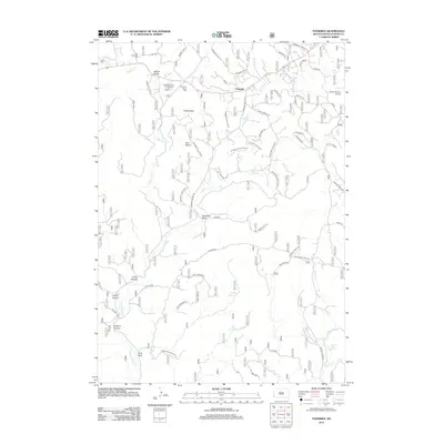
2012 Map of Fourmile
USGS Topo · Published 2012About this map
The settlement of Fourmile serves as the focal point for this survey of Custer County, situated near a complex network of drainage basins and distinct geological formations. The landscape is defined by its vertical variety, ranging from the prominent heights of Castle Rock and Twin Sisters to the deep cuts of Griffis Canyon and Layton Canyon. Water management is evident through the presence of several stock ponds and catchments, including Ventling Reservoir and Ward Reservoir, alongside natural sources like Carroll Creek Spring and Spar Spring. The transition from recreational use to local infrastructure is marked by the proximity of the Comanche Park Campground and Harrymill Picnic Area to the Custer County Airport in the northeast. A dense network of forest roads and namesake paths, such as Bebbington and Stagg Rd, reveals the continued importance of land access for both transit and resource management in this region of South Dakota.
Find a feature on this map
59 named features on this map. Tap any name to fly to it.
Don’t see what you’re looking for? This feature index may not catch every label — zoom into the map to look around manually.
Map Details
Editions of this 2012 Fourmile Map
This is the sole edition of this map. No revisions or reprints were ever made.
Other maps of this area

1896 · Harney Peak
USGS Topo · 1:125,000

1901 · Harney Peak
USGS Topo · 1:125,000

1954 · Fourmile
USGS Topo · 1:24,000

1954 · Custer
USGS Topo · 1:24,000

1954 · Berne
USGS Topo · 1:24,000

1954 · Jewel Cave SE
USGS Topo · 1:24,000

1955 · Jewel Cave
USGS Topo · 1:24,000
1955 · Argyle
USGS Topo · 1:24,000

1955 · Signal Hill
USGS Topo · 1:24,000
1955 · Cicero Peak
USGS Topo · 1:24,000