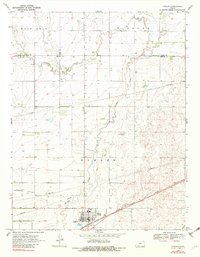
1969 Map of Fowler
USGS Topo · Published 1982About this map
Fowler serves as the primary hub of this High Plains landscape, where the Chicago Rock Island and Pacific railroad cuts a diagonal path toward the southwest. The town's grid is clearly defined, situated just south of where Crooked Creek meanders through the terrain. This watercourse defines much of the local topography, carving through areas identified as Wilburn and East Hess.
Find a feature on this map
16 named features on this map. Tap any name to fly to it.
Don’t see what you’re looking for? This feature index may not catch every label — zoom into the map to look around manually.
Map Details
Editions of this 1969 Fowler Map
2 editions found
Other maps of this area

1892 · Meade
USGS Topo · 1:125,000

1892 · Dodge
USGS Topo · 1:125,000

1955 · Dodge City
USGS Topo · 1:250,000

1958 · Dodge City
USGS Topo · 1:250,000

1959 · Dodge City
USGS Topo · 1:250,000

1963 · Meade
USGS Topo · 1:24,000

1967 · Fowler SE
USGS Topo · 1:24,000

1967 · Fowler SW
USGS Topo · 1:24,000

1967 · Minneola
USGS Topo · 1:24,000

1969 · Meade NE
USGS Topo · 1:24,000