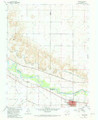
1960 Map of Fowler
USGS Topo · Published 1973About this map
The Arkansas River corridor dominates this landscape, serving as the primary artery for a complex network of irrigation and transportation in the high plains. In the early 1960s, the town of Fowler serves as a local hub, featuring a Jr High Sch and a community Cem on its outskirts. The importance of water management is evident in the engineered paths of the Oxford Farmers Ditch, Colorado Canal, and the Rocky Ford Highline Canal, which divert river water to support regional agriculture. Two major railroads, the Atchison Topeka and Santa Fe and the Missouri Pacific, parallel the river valley, connecting the small settlements of Hamlet and Pultney. This survey highlights the intersection of industrial rail transport and agricultural irrigation that defined the rural economy in this part of Colorado.
Find a feature on this map
21 named features on this map. Tap any name to fly to it.
Don’t see what you’re looking for? This feature index may not catch every label — zoom into the map to look around manually.
Map Details
Editions of this 1960 Fowler Map
3 editions found
Other maps of this area

1891 · Catlin
USGS Topo · 1:125,000

1891 · Nepesta
USGS Topo · 1:125,000

1893 · Nepesta
USGS Topo · 1:125,000

1893 · Catlin
USGS Topo · 1:125,000

1904 · Nepesta
USGS Topo · 1:125,000

1954 · Olney Springs
USGS Topo · 1:24,000

1954 · Elder
USGS Topo · 1:24,000

1954 · Lamar
USGS Topo · 1:250,000

1954 · Pueblo
USGS Topo · 1:250,000

1957 · Pueblo
USGS Topo · 1:250,000