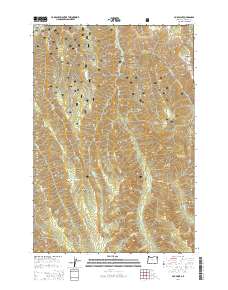
2014 Map of Fox Point
USGS Topo · Published 2014About this map
Wallowa National Forest land defines this portion of northeastern Oregon, where high-elevation landmarks like Bald Knob and Huckleberry Mountain overlook a complex network of drainages and springs. The landscape is marked by steep elevation changes, with Big Canyon and Baker Canyon carving through the terrain near the high point of Fox Point. This area lacks permanent settlements, instead showing a wilderness infrastructure of forest development roads such as Nat For Dev Rd 050 and Nat For Dev Rd 8250. Water sources are critical identifiers for this region, including multiple named points like Bearwallow Spring, Hideaway Spring, and Standley Spring. To the south, the Lake Basin and Goat Mountain provide significant topographical relief, while Big Flat in the northeast offers one of the few level stretches in an otherwise deeply dissected volcanic plateau.
Find a feature on this map
36 named features on this map. Tap any name to fly to it.
Don’t see what you’re looking for? This feature index may not catch every label — zoom into the map to look around manually.
Map Details
Editions of this 2014 Fox Point Map
This is the sole edition of this map. No revisions or reprints were ever made.
Other maps of this area

1906 · Telocaset
USGS Topo · 1:125,000

1955 · Grangeville
USGS Topo · 1:250,000

1957 · Enterprise
USGS Topo · 1:62,500

1957 · Sled Springs
USGS Topo · 1:62,500

1959 · Grangeville
USGS Topo · 1:250,000

1964 · Wallowa
USGS Topo · 1:24,000

1964 · Minam
USGS Topo · 1:24,000

1965 · Fox Point
USGS Topo · 1:24,000
1965 · Mount Moriah
USGS Topo · 1:24,000
1965 · Mt. Fanny
USGS Topo · 1:24,000