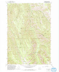
1993 Map of Fox Point
USGS Topo · Published 1993About this map
Wallowa National Forest dominates this northeastern Oregon landscape, where the high ridges of the Eagle Cap Wilderness meet deep drainage systems. The map illustrates a high-elevation environment defined by prominent peaks like Huckleberry Mountain and Goat Mountain, with the titular Fox Point serving as a central geographic marker. Water sources are critical in this terrain, as evidenced by numerous named springs such as Bearwallow Spring, Hideaway Spring, and Standley Spring which support the area's hydrology.
Find a feature on this map
38 named features on this map. Tap any name to fly to it.
Don’t see what you’re looking for? This feature index may not catch every label — zoom into the map to look around manually.
Map Details
Editions of this 1993 Fox Point Map
This is the sole edition of this map. No revisions or reprints were ever made.
Other maps of this area

1906 · Telocaset
USGS Topo · 1:125,000

1955 · Grangeville
USGS Topo · 1:250,000

1957 · Enterprise
USGS Topo · 1:62,500

1957 · Sled Springs
USGS Topo · 1:62,500

1959 · Grangeville
USGS Topo · 1:250,000

1964 · Wallowa
USGS Topo · 1:24,000

1964 · Minam
USGS Topo · 1:24,000

1965 · Fox Point
USGS Topo · 1:24,000
1965 · Mount Moriah
USGS Topo · 1:24,000
1965 · Mt. Fanny
USGS Topo · 1:24,000