
1954 Map of Foxboro
USGS Topo · Published 1984About this map
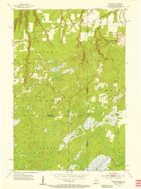
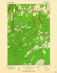
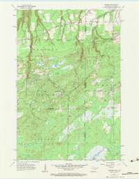
Foxboro and Harlis stand as primary settlements on this 1954 landscape, positioned along the vital rail corridors that defined commerce in the borderlands between Wisconsin and Minnesota. The territory is a complex mosaic of state forest land and water, shaped significantly by the Great Northern and the Minneapolis St Paul And Sault Ste Marie railroads. An Old Railroad Grade further south indicates the shifting infrastructure of the era, while several Gravel Pits suggest the local industrial activity required to maintain these transit lines. The presence of the Summit Cem near the state boundary provides a specific point of interest for genealogists tracing families in the Summit and Holyoke areas. The drainage patterns of the Net River and Balsam Creek emphasize the low-lying, marshy character of the terrain surrounding Black Lake.
Find a feature on this map
22 named features on this map. Tap any name to fly to it.
Don’t see what you’re looking for? This feature index may not catch every label — zoom into the map to look around manually.
Map Details
Editions of this 1954 Foxboro Map
4 editions found
Historical Maps of Summit Through Time
58 maps found

1945 Highland
Douglas County, WI

1949 Highland
Douglas County, WI

1949 Patzau
Douglas County, WI

1954 Amnicon Lake
Douglas County, WI

1954 Borea
Douglas County, WI

1954 Cloverland
Douglas County, WI
1954 Foxboro
Douglas County, WI

1954 Lyman Lake
Douglas County, WI

1954 Parkland
Douglas County, WI

1954 Patzau
Douglas County, WI

1954 Poplar NE
Douglas County, WI

1954 South Range
Douglas County, WI

1954 Sunnyside
Douglas County, WI

1955 Patzau
Douglas County, WI

1961 Cloverland
Douglas County, WI

1961 Ellison Lake
Douglas County, WI

1961 Lyman Lake
Douglas County, WI

1971 Chittamo
Douglas County, WI

1971 Chittamo NE
Douglas County, WI

1981 Bennett
Douglas County, WI

1982 Buckety Creek
Douglas County, WI

1982 Minong Flowage
Douglas County, WI

1983 Black Lake
Douglas County, WI

1983 Dairyland
Douglas County, WI

1983 Empire Swamp
Douglas County, WI

1983 Moose Junction
Douglas County, WI

1983 Scovils Lake
Douglas County, WI

1984 Ellison Lake
Douglas County, WI

1984 Island Lake
Douglas County, WI

1984 Lake Minnesuing
Douglas County, WI

1984 Metzger Lake
Douglas County, WI

1984 Oulu
Douglas County, WI

2022 Amnicon Lake
Douglas County, WI

2022 Bennett
Douglas County, WI

2022 Black Lake
Douglas County, WI

2022 Borea
Douglas County, WI

2022 Buckety Creek
Douglas County, WI

2022 Chittamo
Douglas County, WI

2022 Chittamo NE
Douglas County, WI

2022 Cloverland
Douglas County, WI

2022 Dairyland
Douglas County, WI

2022 Ellison Lake
Douglas County, WI

2022 Empire Swamp
Douglas County, WI

2022 Foxboro
Douglas County, WI

2022 Island Lake
Douglas County, WI

2022 Lake Minnesuing
Douglas County, WI

2022 Lyman Lake
Douglas County, WI

2022 Metzger Lake
Douglas County, WI

2022 Minong Flowage
Douglas County, WI

2022 Moose Junction
Douglas County, WI

2022 Oulu
Douglas County, WI

2022 Oulu OE N
Douglas County, WI

2022 Parkland
Douglas County, WI

2022 Patzau
Douglas County, WI

2022 Poplar NE
Douglas County, WI

2022 Scovils Lake
Douglas County, WI

2022 South Range
Douglas County, WI

2022 Sunnyside
Douglas County, WI