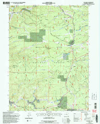
1992 Map of Foxpark
USGS Topo · Published 1996About this map
Foxpark and the surrounding high-altitude timberlands are documented in this detailed study of the southeast Wyoming landscape. The Union Pacific Railroad cuts a north-south path through the forest, connecting small siding settlements and logging sites like Gramm, Wyocolo, and Collins (Site). The timber economy and early 20th-century mountain life are evident through the network of access roads, including the Douglas Platte Access Road, which lead to resource extraction points like the American Mine and recreational outposts like the Lake Creek Resort.
Find a feature on this map
39 named features on this map. Tap any name to fly to it.
Don’t see what you’re looking for? This feature index may not catch every label — zoom into the map to look around manually.
Map Details
Editions of this 1992 Foxpark Map
2 editions found
Other maps of this area

1906 · Medicine Bow
USGS Topo · 1:125,000

1908 · Medicine Bow
USGS Topo · 1:125,000

1950 · Northgate
USGS Topo · 1:24,000

1950 · Kings Canyon
USGS Topo · 1:24,000

1952 · Northgate
USGS Topo · 1:24,000

1952 · Kings Canyon
USGS Topo · 1:24,000

1954 · Rawlins
USGS Topo · 1:250,000

1954 · Craig
USGS Topo · 1:250,000

1955 · Old Roach
USGS Topo · 1:24,000

1955 · Kings Canyon
USGS Topo · 1:62,500