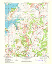
1970 Map of Foyil
USGS Topo · Published 1972About this map
Industrial extraction and water management dominate this Rogers County landscape as it appeared in the early 1970s. The western portion of the map is defined by the sprawling Oologah Reservoir, which flooded the valley where the Verdigris River meets Blue Creek. East of the reservoir, a massive corridor of strip mines cuts a jagged path through the terrain, illustrating the scale of coal operations near Foyil and Oowala. These excavations follow the ridge lines between distinctive landforms like Round Mound and Twin Mounds. The St Louis-San Francisco railroad bisects the area, serving the mining operations and passing by Sequoyah Siding. For local historians, the sheet preserves the location of rural landmarks including New Hope Ch, Wards Grove Cem, and Oowala Cem nestled among the winding tributaries of Dog Creek.
Find a feature on this map
31 named features on this map. Tap any name to fly to it.
Don’t see what you’re looking for? This feature index may not catch every label — zoom into the map to look around manually.
Map Details
Editions of this 1970 Foyil Map
2 editions found
Other maps of this area

1896 · Pryor
USGS Topo · 1:125,000

1901 · Claremore
USGS Topo · 1:125,000

1901 · Nowata
USGS Topo · 1:125,000

1901 · Vinita
USGS Topo · 1:125,000

1901 · Pryor
USGS Topo · 1:125,000

1913 · Vinita
USGS Topo · 1:125,000

1914 · Nowata
USGS Topo · 1:125,000

1914 · Claremore
USGS Topo · 1:125,000

1916 · Claremore
USGS Topo · 1:125,000

1954 · Tulsa
USGS Topo · 1:250,000