1970 Map of Foyil
USGS Topo · Published 1982About this map
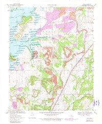
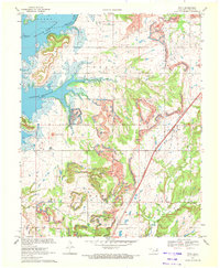
Oologah Lake dominates the northwestern corner of this Rogers County landscape, where the Verdigris River was impounded to reshape the local topography. This 1970s era documentation, updated in the early 1980s, reveals a countryside heavily defined by surface mining operations, with numerous areas marked as Strip Mine or Reclaimed Strip Mine surrounding the town of Foyil. The industrial footprint of these mines and the nearby Oil Field exists alongside a more traditional rural network of family and community landmarks.
Find a feature on this map
32 named features on this map. Tap any name to fly to it.
Don’t see what you’re looking for? This feature index may not catch every label — zoom into the map to look around manually.
Map Details
Editions of this 1970 Foyil Map
2 editions found
Other maps of this area

1896 · Pryor
USGS Topo · 1:125,000

1901 · Claremore
USGS Topo · 1:125,000

1901 · Nowata
USGS Topo · 1:125,000

1901 · Vinita
USGS Topo · 1:125,000

1901 · Pryor
USGS Topo · 1:125,000

1913 · Vinita
USGS Topo · 1:125,000

1914 · Nowata
USGS Topo · 1:125,000

1914 · Claremore
USGS Topo · 1:125,000

1916 · Claremore
USGS Topo · 1:125,000

1954 · Tulsa
USGS Topo · 1:250,000