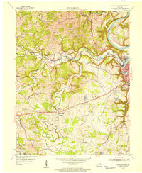
1953 Map of Frankfort West
USGS Topo · Published 1955About this map
Frankfort serves as the focal point of this mid-century topography, where the Kentucky River winds sharply through a landscape defined by deep valleys and high ridges. The state's administrative center is clearly marked by the State Capitol, while the city's residential and industrial footprint expands into neighborhoods like Bellepoint and Cloverdale. Transportation networks are essential to this riverfront economy, notably the Louisville and Nashville Railroad which follows the contours of Benson Creek.
Find a feature on this map
53 named features on this map. Tap any name to fly to it.
Don’t see what you’re looking for? This feature index may not catch every label — zoom into the map to look around manually.
Map Details
Editions of this 1953 Frankfort West Map
This is the sole edition of this map. No revisions or reprints were ever made.
Other maps of this area

1906 · Lockport
USGS Topo · 1:48,000

1908 · Lockport
USGS Topo · 1:62,500

1922 · Frankfort
USGS Topo · 1:48,000

1923 · Waddy
USGS Topo · 1:48,000

1924 · Frankfort
USGS Topo · 1:62,500

1925 · Mount Eden
USGS Topo · 1:48,000

1927 · Mount Eden
USGS Topo · 1:62,500

1928 · New Castle
USGS Topo · 1:48,000

1932 · New Castle
USGS Topo · 1:62,500

1951 · Lawrenceburg
USGS Topo · 1:24,000