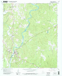
1964 Map of Franklin
USGS Topo · Published 1987About this map
The Chattahoochee River carves a deep, winding path through Heard County, punctuated by rocky river features like Bush Head Shoals and Daniel Shoals. This mid-1960s landscape centers on the county seat of Franklin, where the Court House, Ernest Mem Hospital, and the County High Sch form the civic core. The road network, including the historic Five Notch Road, connects the town to outlying agricultural and residential communities such as Centralhatchee and Enon Grove.
Find a feature on this map
44 named features on this map. Tap any name to fly to it.
Don’t see what you’re looking for? This feature index may not catch every label — zoom into the map to look around manually.
Map Details
Editions of this 1964 Franklin Map
3 editions found
Other maps of this area

1899 · Wedowee
USGS Topo · 1:125,000

1902 · Wedowee
USGS Topo · 1:125,000

1953 · Atlanta
USGS Topo · 1:250,000

1957 · Atlanta
USGS Topo · 1:250,000

1958 · Atlanta
USGS Topo · 1:250,000

1964 · Hogansville
USGS Topo · 1:24,000

1964 · Glenn
USGS Topo · 1:24,000

1964 · Hillcrest
USGS Topo · 1:24,000

1964 · Roopville
USGS Topo · 1:24,000
1964 · Franklin
USGS Topo · 1:24,000