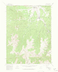
1957 Map of Fraser
USGS Topo · Published 1974About this map
Tabernash and Fraser serve as the primary hubs in this high-altitude corridor during the late 1950s, where the Denver and Rio Grande Western railroad tracks follow the course of the Fraser River. The landscape is defined by the massive engineering of the Continental Divide, featuring the historic Moffat Tunnel and the August P Gumlick Tunnel (also known as the Jones Pass Tunnel), which highlight the region's role in water diversion and transcontinental transport. Recreation and resource management are central to the area's identity, evidenced by the Berthoud Pass Ski Area, the First Creek Ski Cabin, and the Fraser Experimental Sta. Numerous trails like the High Lonesome Trail and Idlewild Trail wind through the Arapaho National Forest, connecting peaks like Byers Peak and Mt Nystrom to the valley settlements below.
Find a feature on this map
80 named features on this map. Tap any name to fly to it.
Don’t see what you’re looking for? This feature index may not catch every label — zoom into the map to look around manually.
Map Details
Editions of this 1957 Fraser Map
4 editions found
Other maps of this area

1903 · Georgetown
USGS Topo · 1:62,500

1905 · Central City
USGS Topo · 1:62,500

1905 · Georgetown
USGS Topo · 1:62,500

1910 · Central City
USGS Topo · 1:62,500

1912 · Central City
USGS Topo · 1:62,500

1915 · Longs Peak
USGS Topo · 1:125,000

1919 · Rocky Mountain National Park
USGS Topo · 1:125,000

1924 · Montezuma
USGS Topo · 1:62,500

1924 · Fraser
USGS Topo · 1:62,500

1926 · Fraser
USGS Topo · 1:62,500