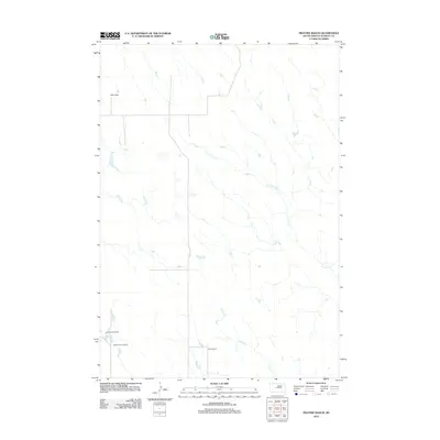
2012 Map of Fratzke Ranch
USGS Topo · Published 2012About this map
Stanley County ranching operations define this high-plains landscape, where family-named holdings like Miller Ranch and the Fratzke Ranch occupy the expansive terrain north of the Bad River. The map documents a sparsely populated region of South Dakota where water sources and property boundaries dictate the layout of the land. Seasonal drainages such as Lance Cr and Brush Cr provide critical water for livestock, while the distinctive Lance Cr Holes suggest localized depressions or water catchments essential for high-country grazing. Near the western edge, the Lyle Hedman Ranch and Ralph Hedman Ranch sit in close proximity, reflecting the multi-generational ranching legacy typical of this part of the Great Plains in the early 21st century.
Find a feature on this map
7 named features on this map. Tap any name to fly to it.
Don’t see what you’re looking for? This feature index may not catch every label — zoom into the map to look around manually.
Map Details
Editions of this 2012 Fratzke Ranch Map
This is the sole edition of this map. No revisions or reprints were ever made.
Other maps of this area

1954 · Pierre
USGS Topo · 1:250,000

1958 · Pierre
USGS Topo · 1:250,000

1980 · Princes Ranch
USGS Topo · 1:25,000
1982 · Doty Ridge
USGS Topo · 1:24,000

1982 · Sansarc
USGS Topo · 1:24,000

1982 · Hayes South
USGS Topo · 1:24,000

1982 · Hohrman Ranch
USGS Topo · 1:24,000

1983 · Hayes North
USGS Topo · 1:24,000

1983 · Standing Butte
USGS Topo · 1:24,000
1983 · Standing Butte SW
USGS Topo · 1:24,000