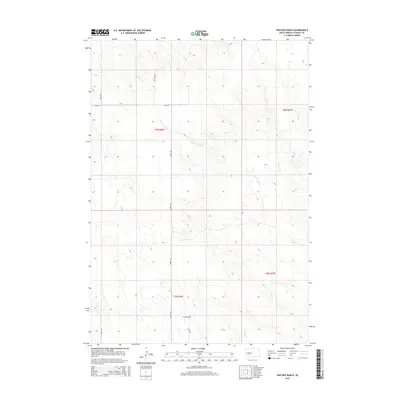
2015 Map of Fratzke Ranch
USGS Topo · Published 2015About this map
Fratzke Ranch occupies a central position in this prairie landscape, providing a primary point of reference within the extensive grid of the Public Land Survey System. The area is defined by the winding paths of intermittent waterways, most notably the seasonal pools of Lance Cr Holes and the drainage of Lance Cr. These features, along with Brush Cr in the southern portion of the quadrangle, illustrate the drainage patterns of the high plains in Stanley County.
Find a feature on this map
13 named features on this map. Tap any name to fly to it.
Don’t see what you’re looking for? This feature index may not catch every label — zoom into the map to look around manually.
Map Details
Editions of this 2015 Fratzke Ranch Map
This is the sole edition of this map. No revisions or reprints were ever made.
Other maps of this area

1954 · Pierre
USGS Topo · 1:250,000

1958 · Pierre
USGS Topo · 1:250,000

1980 · Princes Ranch
USGS Topo · 1:25,000
1982 · Doty Ridge
USGS Topo · 1:24,000

1982 · Sansarc
USGS Topo · 1:24,000

1982 · Hayes South
USGS Topo · 1:24,000

1982 · Hohrman Ranch
USGS Topo · 1:24,000

1983 · Hayes North
USGS Topo · 1:24,000

1983 · Standing Butte
USGS Topo · 1:24,000
1983 · Standing Butte SW
USGS Topo · 1:24,000