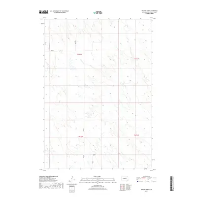
2017 Map of Fratzke Ranch
USGS Topo · Published 2017About this map
Fratzke Ranch occupies a central role in this prairie landscape of Stanley County, positioned where local routes like Blue Pl and 258th Ave converge. The terrain is defined by the ephemeral drainage patterns of the northern plains, featuring the winding course of Lance Cr and the intermittent Lance Cr Holes. This 2017 study illustrates the persistence of ranching infrastructure and land management divisions within the Public Land Survey System, marked by sections across t6n r26e and surrounding townships. Water management in this semi-arid environment is highlighted by the presence of Brush Cr and various unnamed small tanks or ponds scattered across the rolling rangeland. The map provides a clear record of modern rural access through a network of section-line roads, including 256th Ave and 202nd St, serving the dispersed homesteads of central South Dakota.
Find a feature on this map
13 named features on this map. Tap any name to fly to it.
Don’t see what you’re looking for? This feature index may not catch every label — zoom into the map to look around manually.
Map Details
Editions of this 2017 Fratzke Ranch Map
This is the sole edition of this map. No revisions or reprints were ever made.
Other maps of this area

1954 · Pierre
USGS Topo · 1:250,000

1958 · Pierre
USGS Topo · 1:250,000

1980 · Princes Ranch
USGS Topo · 1:25,000
1982 · Doty Ridge
USGS Topo · 1:24,000

1982 · Sansarc
USGS Topo · 1:24,000

1982 · Hayes South
USGS Topo · 1:24,000

1982 · Hohrman Ranch
USGS Topo · 1:24,000

1983 · Hayes North
USGS Topo · 1:24,000

1983 · Standing Butte
USGS Topo · 1:24,000
1983 · Standing Butte SW
USGS Topo · 1:24,000