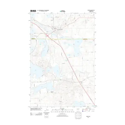
2013 Map of Frazee
USGS Topo · Published 2013About this map
Frazee sits at a critical hydrologic and transportation junction where the Otter Tail River winds through a dense network of glacial lakes. In the early 21st century, this landscape reflects a balance of residential development like Town Lake Estates and the preservation of historical burial grounds including Sacred Heart Cem, Lakeside Cem, and Flatau Cem. The survey shows the southeastward progression of Us-10 as it bypasses the central town, connecting toward the small community of Luce. This area is defined by its water, with large bodies such as Long Lake, Silver Lake, and Wimar Lake dominating the terrain. To the south, the Treasured Bay Resort and Campground illustrates the region's enduring role as a destination for recreation and seasonal residency within Becker and Otter Tail counties.
Find a feature on this map
84 named features on this map. Tap any name to fly to it.
Don’t see what you’re looking for? This feature index may not catch every label — zoom into the map to look around manually.
Map Details
Editions of this 2013 Frazee Map
This is the sole edition of this map. No revisions or reprints were ever made.
Other maps of this area

1912 · Vergas
USGS Topo · 1:62,500

1915 · Perham
USGS Topo · 1:62,500

1915 · Vergas
USGS Topo · 1:62,500

1953 · Brainerd
USGS Topo · 1:250,000

1957 · Brainerd
USGS Topo · 1:250,000

1958 · Brainerd
USGS Topo · 1:250,000

1959 · Toad Mountain
USGS Topo · 1:24,000

1959 · Rochert
USGS Topo · 1:24,000
1959 · Detroit Lakes
USGS Topo · 1:24,000

1965 · Brainerd
USGS Topo · 1:250,000