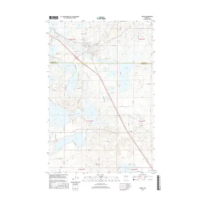
2016 Map of Frazee
USGS Topo · Published 2016About this map
Frazee serves as the central hub of this lakeside landscape, where the Otter Tail River winds through a dense concentration of glacial basins. The town's grid is established along the riverbanks, supported by local landmarks like Sacred Heart Cem and Lakeside Cem. To the southeast, the small settlement of Luce sits along a major transportation corridor that cuts a straight path through the township boundaries of t137n r39w and t138n r39w. The geography is defined by an intricate network of water bodies, including the large expanse of Eagle Lake and the more secluded Rose Lake. This mid-2010s survey details a region where the natural hydrology of Wimar Lake and Long Lake dictates the winding routes of local roads like Wymer Lake Loop and Black Diamond Rd.
Find a feature on this map
94 named features on this map. Tap any name to fly to it.
Don’t see what you’re looking for? This feature index may not catch every label — zoom into the map to look around manually.
Map Details
Editions of this 2016 Frazee Map
This is the sole edition of this map. No revisions or reprints were ever made.
Other maps of this area

1912 · Vergas
USGS Topo · 1:62,500

1915 · Perham
USGS Topo · 1:62,500

1915 · Vergas
USGS Topo · 1:62,500

1953 · Brainerd
USGS Topo · 1:250,000

1957 · Brainerd
USGS Topo · 1:250,000

1958 · Brainerd
USGS Topo · 1:250,000

1959 · Toad Mountain
USGS Topo · 1:24,000

1959 · Rochert
USGS Topo · 1:24,000
1959 · Detroit Lakes
USGS Topo · 1:24,000

1965 · Brainerd
USGS Topo · 1:250,000