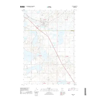
2019 Map of Frazee
USGS Topo · Published 2019About this map
Frazee serves as the central hub of this lake-strewn landscape where the Otter Tail River winds through the northern portion of the map. The settlement pattern is defined by the intersection of numerous water bodies, including Eagle Lake, Graham Lake, and Long Lake, which creates a complex geography of peninsulas and narrow crossings. In the north, Sacred Heart Cem and Lakeside Cem are situated near the town, while the southern reaches feature the smaller settlement of Luce and Flatau Cem. The network of local roads, such as Wymer Lake Loop and Good Oak Loop, reflects the recreational and residential development typical of this region's glaciated terrain. Significant water bodies like Rice Lake and Devils Lake dominate the central and southern quadrants, illustrating the dense hydrological network that has shaped the area's history and growth.
Find a feature on this map
93 named features on this map. Tap any name to fly to it.
Don’t see what you’re looking for? This feature index may not catch every label — zoom into the map to look around manually.
Map Details
Editions of this 2019 Frazee Map
This is the sole edition of this map. No revisions or reprints were ever made.
Other maps of this area

1912 · Vergas
USGS Topo · 1:62,500

1915 · Perham
USGS Topo · 1:62,500

1915 · Vergas
USGS Topo · 1:62,500

1953 · Brainerd
USGS Topo · 1:250,000

1957 · Brainerd
USGS Topo · 1:250,000

1958 · Brainerd
USGS Topo · 1:250,000

1959 · Toad Mountain
USGS Topo · 1:24,000

1959 · Rochert
USGS Topo · 1:24,000
1959 · Detroit Lakes
USGS Topo · 1:24,000

1965 · Brainerd
USGS Topo · 1:250,000