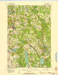
1955 Map of Frederic
USGS Topo · Published 1957About this map
Glacial lakes and small agricultural settlements define this portion of Polk County during the mid-1950s. The Soo Line corridor serves as the primary spine of the region, connecting the hubs of Frederic and Luck while passing through Lewis. The landscape is a mosaic of small woodlots and farmsteads, punctuated by numerous rural educational and religious centers. Notable local landmarks include Zion Ch and the West Sweden Sch, reflecting the community's Scandinavian roots and the importance of decentralized township school districts before the era of major consolidation.
Find a feature on this map
88 named features on this map. Tap any name to fly to it.
Don’t see what you’re looking for? This feature index may not catch every label — zoom into the map to look around manually.
Map Details
Editions of this 1955 Frederic Map
This is the sole edition of this map. No revisions or reprints were ever made.
Other maps of this area
1900 · St Croix Dalles
USGS Topo · 1:62,500
1901 · St Croix Dalles
USGS Topo · 1:62,500
1949 · Hertel
USGS Topo · 1:48,000
1950 · Webster
USGS Topo · 1:48,000
1950 · Grantsburg
USGS Topo · 1:48,000
1950 · Balsam Lake
USGS Topo · 1:62,500
1950 · Turtle Lake
USGS Topo · 1:62,500
1951 · Cumberland
USGS Topo · 1:48,000
1951 · Milltown
USGS Topo · 1:48,000

1951 · Frederic
USGS Topo · 1:48,000