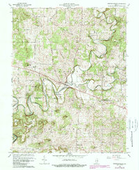
1966 Map of Fredericksburg
USGS Topo · Published 1988About this map
Fredericksburg and the small settlement of McIntosh anchor this mid-century look at the southern Indiana borderland between Washington and Harrison Counties. The winding course of the Blue River dominates the landscape, creating distinct geological formations like Whittman Bottom and the isolated Leatherwood Island. Local topography is heavily marked by family-named rises and hollows, including Wildcat Knob, Stout Hill, and Haiti Hollow. The map records several rural religious centers that served the scattered farmsteads, such as Mt Carmel Ch, Kays Chapel, and Hancock Chapel. Transport is defined by early routes like the Base Line and Hunter Spring Rd, while unique hydrographic features like Organ Springs and Hunter Spring reveal the region's complex karst drainage and water sources for early residents.
Find a feature on this map
45 named features on this map. Tap any name to fly to it.
Don’t see what you’re looking for? This feature index may not catch every label — zoom into the map to look around manually.
Map Details
Editions of this 1966 Fredericksburg Map
3 editions found
Other maps of this area

1946 · Depauw
USGS Topo · 1:24,000

1947 · Hardinsburg
USGS Topo · 1:24,000

1948 · Milltown
USGS Topo · 1:24,000

1949 · Hardinsburg
USGS Topo · 1:24,000

1950 · Salem
USGS Topo · 1:24,000

1950 · Becks Mill
USGS Topo · 1:24,000

1950 · Palmyra
USGS Topo · 1:24,000

1953 · Fredericksburg
USGS Topo · 1:24,000
1954 · Crandall
USGS Topo · 1:24,000

1956 · Vincennes
USGS Topo · 1:250,000