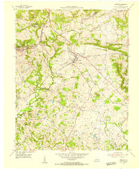
1954 Map of Fredonia
USGS Topo · Published 1955About this map
Fredonia serves as the central hub of this mid-century survey, where the Illinois Central railroad intersects the town's local road network near the Fredonia Valley Quarry. The landscape is defined by its industrial character, specifically the fluorite mining operations that once fueled the local economy. Notable extractive sites include the King Mine (Fluorite), Haffaw Mine (Fluorite), and the Penn Salt Fluorite Mill, indicating a period of significant mineral production in this corner of Kentucky.
Find a feature on this map
45 named features on this map. Tap any name to fly to it.
Don’t see what you’re looking for? This feature index may not catch every label — zoom into the map to look around manually.
Map Details
Editions of this 1954 Fredonia Map
2 editions found
Other maps of this area

1908 · Princeton
USGS Topo · 1:62,500

1909 · Providence
USGS Topo · 1:62,500

1910 · Princeton
USGS Topo · 1:62,500

1916 · Fords Ferry
USGS Topo · 1:62,500

1921 · Fords Ferry
USGS Topo · 1:48,000

1925 · Cave In Rock
USGS Topo · 1:62,500

1928 · Eddyville
USGS Topo · 1:48,000

1931 · Eddyville
USGS Topo · 1:62,500

1936 · Eddyville
USGS Topo · 1:48,000

1936 · Grand Rivers
USGS Topo · 1:24,000