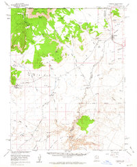
1954 Map of Fredonia
USGS Topo · Published 1963About this map
Pipe Spring National Monument stands as a focal point in this 1954 landscape, marking a crucial oasis where desert springs meet the rising sandstone of the Shinarump Cliffs. The map reveals a remote ranching and transit network, featuring isolated outposts like Indian Moccasin and the Twomile Corrals. Water is the primary determinant of movement here, evidenced by the numerous named water sources such as Red Cliffs Spring and Quickwater Spring, as well as established livestock routes through the Moccasin Mountains. Along the drainage of Kanab Creek, the inclusion of Nagles Crossing and Booze Crossing indicates where travelers and cattle once forged the seasonal waterway. This mid-century survey, produced in cooperation with the Atomic Energy Commission, documents a transitional era where an abandoned landing strip near Johnson Run sits near newer infrastructure like the regional pipeline.
Find a feature on this map
60 named features on this map. Tap any name to fly to it.
Don’t see what you’re looking for? This feature index may not catch every label — zoom into the map to look around manually.
Map Details
Editions of this 1954 Fredonia Map
3 editions found

Other maps of this area

1886 · Kanab
USGS Topo · 1:250,000

1886 · Kaibab
USGS Topo · 1:250,000

1953 · Cedar City
USGS Topo · 1:250,000

1953 · Grand Canyon
USGS Topo · 1:250,000

1954 · Kanab SW
USGS Topo · 1:24,000

1954 · Fredonia NW
USGS Topo · 1:24,000

1954 · Kanab SE
USGS Topo · 1:24,000

1954 · Shinarump NW
USGS Topo · 1:24,000

1954 · Short Creek SE
USGS Topo · 1:24,000

1954 · Fredonia SW
USGS Topo · 1:24,000