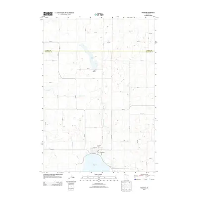
2013 Map of Freeborn
USGS Topo · Published 2013About this map
Freeborn sits at the northern edge of Freeborn Lake, serving as a central hub for this agricultural portion of southern Minnesota. The landscape is defined by its water management and glacial topography, with the Cobb River winding through the west and the Cobb Cr Ditch reflecting decades of drainage efforts to support the surrounding farmland. Small water bodies like Trenton Lake and Boot Cr are scattered across the terrain, alongside evidence of long-standing community sites such as Seven Day Cem and the Freeborn Cem. The town itself is compactly arranged around Lafayette ST and Co HWY-29, where the local Po indicates its continued role as a local service center. This survey documents the intersection of natural hydrology and systematic rural development along the Waseca Co and Freeborn Co line.
Find a feature on this map
44 named features on this map. Tap any name to fly to it.
Don’t see what you’re looking for? This feature index may not catch every label — zoom into the map to look around manually.
Map Details
Editions of this 2013 Freeborn Map
This is the sole edition of this map. No revisions or reprints were ever made.
Other maps of this area

1954 · Albert Lea
USGS Topo · 1:62,500

1954 · Mason City
USGS Topo · 1:250,000

1955 · Wells
USGS Topo · 1:62,500

1957 · Mason City
USGS Topo · 1:250,000

1958 · Mason City
USGS Topo · 1:250,000

1967 · Waldorf
USGS Topo · 1:24,000

1967 · Freeborn
USGS Topo · 1:24,000
1967 · Otisco
USGS Topo · 1:24,000
1967 · Matawan
USGS Topo · 1:24,000

1967 · Hartland
USGS Topo · 1:24,000